Misleading GPS, Philosophy of Maps, And You
The oft-quoted saying “all models are wrong, but some are useful” is a tounge-in-cheek way of saying that at some level, tools we use to predict how the world behaves will differ from reality in some measurable way. This goes well beyond the statistics classroom it is most often quoted in, too, and is especially apparent to anyone who has used a GPS mapping device of any sort. While we might think that our technological age can save us from the approximations of maps and models, there are a number of limitations with this technology that appear in sometimes surprising ways. [Kyle] has an interesting writeup about how maps can be wrong yet still be incredibly useful especially in the modern GPS-enabled world.
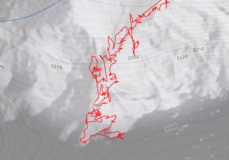
[Kyle] is coming to us with a background in outdoor travel, involving all kinds of activities like hiking and backcountry skiing. When dealing with GPS tracking under these conditions, often the user’s actual position will deviate from their recorded position by a significant margin. Obvious causes like a loss of GPS signal are one thing, but there are some other reasons for this behavior. GPS can be off by tens of meters, so the question then becomes whether or not mapping software should record these errors or attempt to guess where it thinks the most likely location is, based on available data like barometric pressure, existing trails, elevation profiles, and other data. Especially in areas where the elevation changes rapidly, these errors can compound quickly and provide some truly mystifying data. Where mapping software draws these distinctions is a matter of active debate in these communities, with some taking more approximate routes that make more sense while sacrificing the raw data, and others letting the GPS pins fall where they may.
For anyone who’s been confused by Strava or Garmin data at the end of a run, hike, or bike ride, this is a fairly informative explanation of why the GPS data might differ from the actual distance of any of these activities. [Kyle] also notes that unless you’re out with a measuring wheel (and perhaps even then) any method to determine a true distance like this will have some amount of approximation or error. The closest technological solution to a problem like this we’ve seen is this GPS receiver which claims centimeter-level precision using some unique tricks.
from Blog – Hackaday https://ift.tt/fOqk4KB


Comments
Post a Comment